
I started this work because I wanted to know whether GPS tracking devices could actually save someone in a Nigerian kidnapping scenario. Beyond what theory suggests or sales brochures claim, in the real conditions where these things happen — the bush off the Abuja-Kaduna road, the forest reserves of southern Kaduna, the hinterland villages of Zamfara, where mass abductions have become a regular part of the news.
The honest answer, after months of building a model to test the question rigorously, is more complicated than I expected. The technology mostly exists, and the math mostly works. Yet what is missing is something the technology cannot fix, and that is the finding I was not prepared for when I started.
And so i asked.
Is tracking a conceivable option for kidnapping intervention?
I work as a researcher and journalist at HumAngle, a Nigerian newsroom focused on conflict reporting. Over the last few years, I have spent a lot of time looking at conflict data — building datasets on weapons seizures, mapping incidents, and trying to understand the patterns of armed conflicts in ungoverned forest communities.
Kidnapping has been one of the consistent issues I observe in that work. It has gone from being a thing that happened to specific high-value targets to a thing that happens to schoolchildren, market traders, farmers walking home, and drivers on interstate roads.
The question of whether tracking devices could help has come up in conversations with security professionals, with families of victims, and with journalists who cover this beat. The answer is usually dismissive. Some people say yes, in theory. Some say no, the bush is too remote. Nobody I asked had actually tested it.
So I decided to build a framework for testing it — a way of measuring whether any device could work, under what conditions, and with what minimum standards.
The framework is called the Operational Reliability Score, or ORS. It assigns a number between 0 and 1 to a tracking system, accounting for four things that can go wrong: the battery, the signal, the GPS accuracy, and the human chain. A score above 0.60 means the system is good enough to act on. Below 0.40 means the system cannot be trusted. The range in between is the uncertain zone where most real deployments live.
Building the framework took longer than I thought. Some of the assumptions I started with turned out to be wrong, and some of the questions I had not thought to ask turned out to be the ones that mattered most.
The first thing i threw out of the model
The first version of the ORS treated the battery-signal relationship as a number that gradually erodes performance as battery levels drop. The implication was that a device's signal at 80% battery works perfectly. At 50% battery, the signal works a little worse. At 20%, it works badly. I built tier definitions to match this assumption and weighted them carefully.
Then I sat down to write the public-facing explanation of the model, and tried to use my phone as an analogy. My phone's network signal when the battery is at 2% is the same as at 100%. The screen is the same brightness. Calls connect at the same speed. The phone simply runs out of battery and turns off. There is no slow degradation curve from the battery itself. There is full performance, and then there is nothing.
I had to rebuild the battery component of the ORS from the ground up. The correct model is a question of duration, not a degradation curve. Will the device last as long as the event? Either it will or it will not. There is no middle.
That small revision changed the entire picture. Under the old model, a small concealable tracker like the Tracki Mini scored 0.85 on the battery component for a typical scenario. Under the new model, the same device scored 0.40 — because in a Nigerian bush environment with weak mobile signal, the device's battery drain is approximately three times higher than its rated specification. A device that should last 72 hours actually lasts only 19. For any kidnapping event longer than 19 hours, which describes most documented Nigerian kidnapping holding scenarios, the device runs out of battery before the situation is resolved.
Bottom line: signal affects battery consumption, not the other way around.
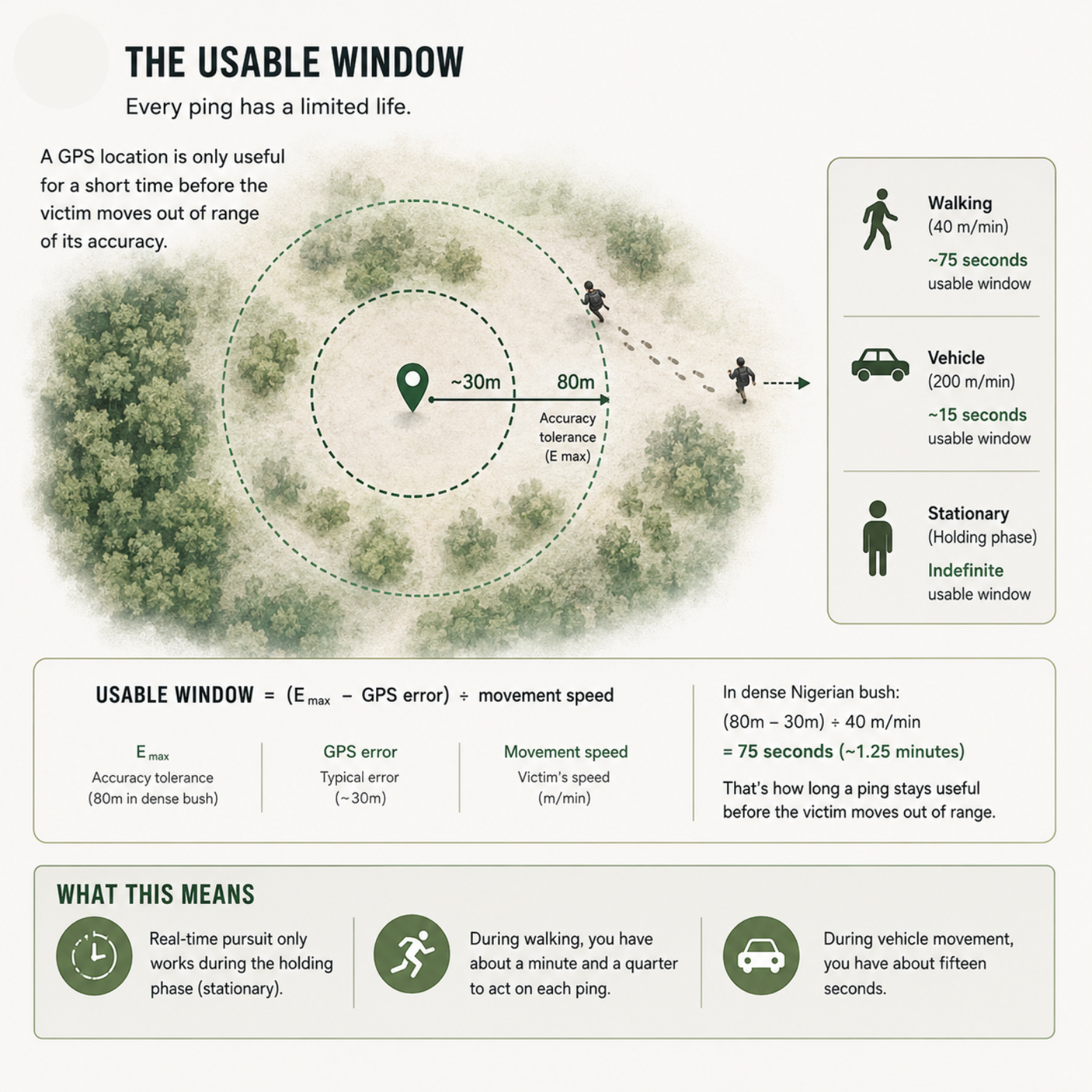
The usable window
The most useful equation in the entire study is also the simplest. It tells you how long a single GPS location stays useful before the victim moves out of range:
Usable window = (GPS accuracy tolerance − current GPS error) ÷ victim movement speed
In dense Nigerian bush, the GPS accuracy tolerance I worked with is 80 metres. Grounded in published evidence, it is the conservative outer edge of what consumer GPS devices can deliver under heavy tree canopy. The GPS error at any given moment is typically around 30 metres. That leaves a 50-metre buffer of useful information around the reported location.
A person being marched through the bush at a fast walking pace covers about 40 metres per minute. So the buffer holds for about 75 seconds. From the moment the device sends a location, the response team has roughly a minute and a quarter before the victim has moved beyond the area that ping describes.
If the captors are moving by vehicle, the buffer holds for about fifteen seconds.
If the victim is being held in one place — the most common phase of Nigerian kidnapping events, when ransom negotiations are underway — the buffer holds indefinitely. The location keeps confirming itself with each new ping.
The math reveals plainly that real-time GPS pursuit only works during the holding phase. The vehicle phase is unrecoverable. The walking phase is recoverable only if there is already a response team in motion.
The ORS model is designed to find, not to chase.
The environment is everything in this model
There is a number in the ORS framework called C_env, which stands for coverage environment. It is the baseline mobile network availability in the area where the device is operating.
-
In a well-covered urban setting, C_env is close to 1.
-
In rural Nigeria generally, the baseline is around 0.65.
-
In the ungoverned hinterland zones where kidnappings concentrate, it is approximately 0.45.
That number comes from the GSMA, the global trade body for mobile network operators. Their humanitarian coverage research found that only 54 percent of internally displaced people in Nigeria live in an area with at least 2G mobile network coverage, compared to 93 percent of the general population. The gap is structural — the product of stagnant infrastructure development and the vandalism of communication towers by armed groups — proving that telecommunications infrastructure has not been built in places where security conditions discourage investment, and where it has been built, the same security conditions that discourage investment are the ones that produce kidnapping.
What this means for the ORS calculation is that even a perfect device — perfect battery, perfect GPS and GSM hardware, perfect operator on the receiving end — cannot score above 0.835 in a C_env 0.45 zone. The limit is determined by network availability in the area, not by the device. In the worst-affected zones, where C_env may be closer to 0.30, the ceiling drops to 0.79, which leaves no margin at all once real device limitations are factored in.
I reflected on this finding. A better device cannot fix what an absent cell tower has already broken. The most expensive tracker on the market produces the same operational result as the cheapest one if neither can transmit.
This is the part of the research that points toward something larger than a single project. If GPS tracking is going to help anyone in Nigerian kidnapping zones, the conversation has to include where the cell towers are, who builds them, and why the most vulnerable populations are the most digitally invisible.
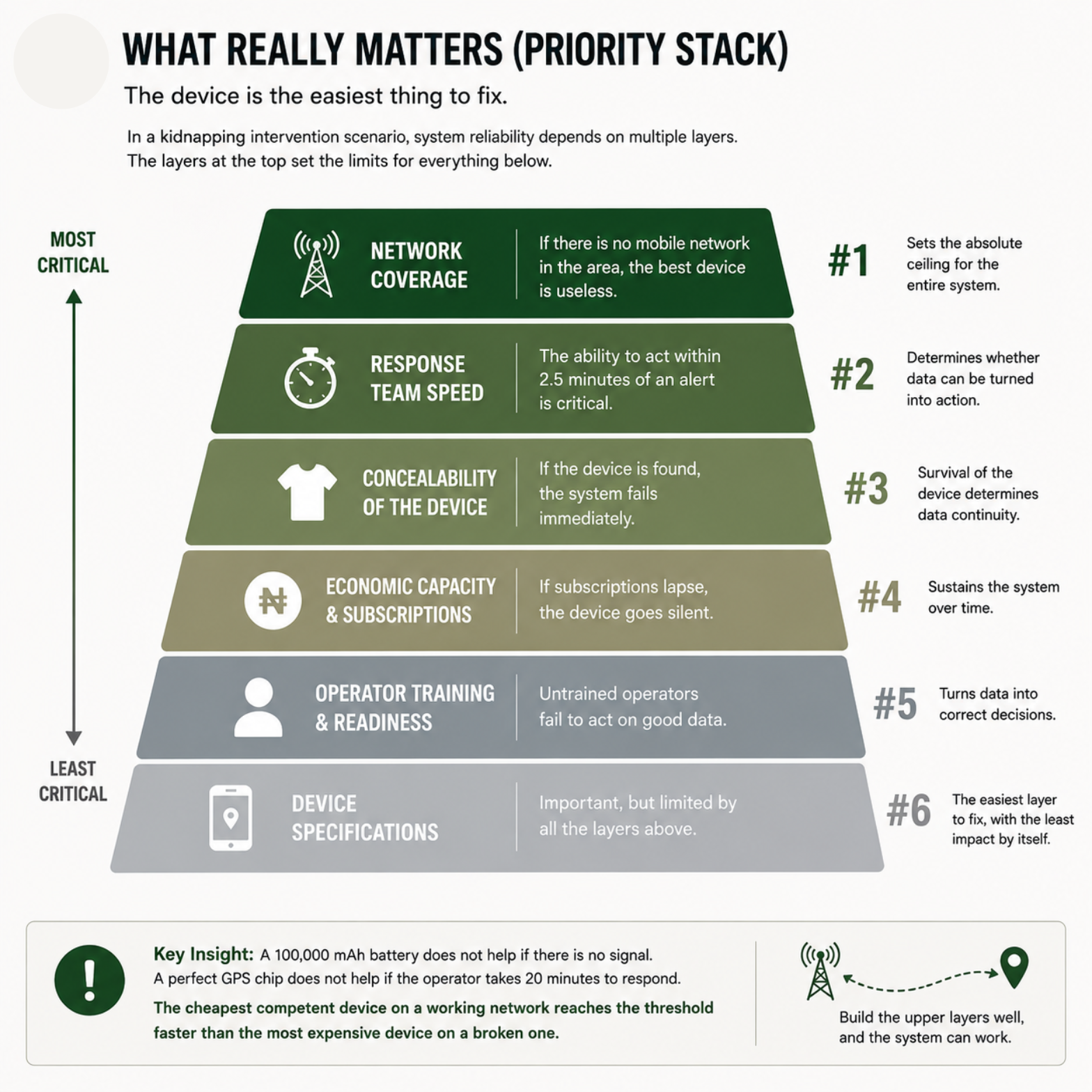
What the model couldn't ignore
I started this project trying to evaluate devices. The work pushed me toward a different framing. The device is the easiest thing to fix. The constraints that actually determine whether tracking can work in Nigerian kidnapping scenarios are, in roughly this order:
-
The presence of a mobile network in the area where the event happens.
-
The ability of a response team to act within two and a half minutes of receiving an alert.
-
The physical concealability of the device on the victim's person, which determines whether it survives the captor's search.
-
The economic capacity of the population to sustain the subscription that keeps the device active.
-
The training of the human operator who reads the alerts and makes the call to dispatch.
-
The technical specifications of the device itself.
That ordering is not what I expected. I expected device specifications to dominate. They are at the bottom of the list because the model showed me, repeatedly, that device improvements run into limits imposed by the layers above. A 100,000 mAh battery does not help if there is no signal. A perfect GPS chip does not help if the operator takes 20 minutes to respond. The cheapest competent device on a working network reaches the operational threshold faster than the most expensive device on a broken one. And there is no point to a device at all if it is found out.
The ideal GPS/GSM tracking scenario
For GPS/GSM tracking to support kidnapping intervention in Nigerian ungoverned bush zones, you need a device that lasts at least 24 hours in weak signal, transmits every 60 seconds, supports 2G, and can be hidden on a person well enough to pass a basic pat-down — and you need a response team that can act within 2.5 minutes of receiving an alert, in a zone where the network is present at least 45 percent of the time. If any one of these conditions falls below standard, the system does not fail partially. It fails completely.
The Device
Battery
The device must have enough charge to last the event duration in the specific signal environment where it will be deployed. In Nigerian ungoverned bush zones, a device at 80% starting charge loses approximately two-thirds of its rated battery life to the power cost of operating in weak signal. A Tracki Mini base unit lasts approximately 19 hours under these conditions. For events beyond 19 hours — which describes most documented Nigerian kidnapping holding scenarios — the base unit is not sufficient. The extended battery case or a higher-capacity device is a minimum requirement.
Minimum battery standard: Device must sustain T_required at C_env-adjusted drain rate, starting from 80% charge. For any event expected to last more than 19 hours in ungoverned zones, the Tracki Mini base unit fails this standard.
Network compatibility
The device must support 2G GSM fallback. In large parts of northern and northwestern Nigeria, 4G and 3G infrastructure is absent or unreliable. A device that only supports 4G produces S = 0 — total signal failure — in those zones, regardless of GPS hardware quality. 2G fallback is the single most important network specification for this deployment context.
Minimum network standard: Confirmed 4G/3G/2G fallback. A device without this cannot be certified for deployment in ungoverned zones.
GPS accuracy
Under dense forest canopy — the primary operational environment — GPS error in low-cost consumer receivers ranges from 20 to 48 metres. The model uses 80 metres as the conservative operational tolerance. Any device that achieves fixes within this range under forest canopy meets the minimum accuracy standard. Devices that cannot acquire a fix under canopy at all fail the standard entirely and trigger T = 0.
Minimum accuracy standard: GPS fix achievable under forest canopy with average error below 80 metres.
Concealability
The device must be concealable on a person without creating a visible outline, audible signal, or detectable heat signature under a systematic search. All indicator LEDs must be disableable. All audible alerts must be disableable. The device must fit within a clothing lining, phone case, or body-worn position that survives a pat-down search. Of the four reviewed devices, only the Tracki Mini meets this standard for body-worn deployment.
Minimum concealability standard: Weight below 40 grams, dimensions fitting within a standard phone case, LED and audio disable confirmed.
The Environment
Coverage zone
The system produces actionable data only where C_env is high enough for the ORS to clear 0.60. The ORS ceiling formula shows that below C_env = 0.33, no device can achieve the actionability threshold regardless of how well every other component performs. The standardised baseline for Nigerian ungoverned zones is C_env = 0.45, which gives an ORS ceiling of 0.835 — conditionally viable, but with no room for additional failure.
Minimum coverage standard: C_env ≥ 0.33 for any intervention-grade reliability. Below this, the system should not be deployed with the expectation of real-time intervention support. It may still produce last-known-location intelligence, but not active tracking.
Terrain tier
The primary operational environment for this study is dense forest and bush — E_max 80 metres. This environment simultaneously stresses P through accelerated battery drain, S through canopy and terrain signal attenuation, and A through GPS multipath interference. It is the only environment where all three components are constrained at the same time. Any device certified for this environment is certified for every less-demanding environment automatically.
Minimum terrain standard: Device must achieve GPS fix and GSM transmission under dense bush canopy in C_env 0.45 conditions.
The Signal
Ping interval
For foot-movement events — the primary intervention scenario — the device must transmit at intervals of 60 seconds or less. At 40 metres per minute victim movement speed, the usable window per ping is approximately 1.25 minutes using the refined formula. A 60-second ping interval is the operational minimum that keeps fresh data arriving within the usable window. Longer intervals produce positional drift that exceeds what a response team can act on.
Minimum ping standard: 60-second or shorter update interval when active tracking mode is engaged.
Signal uptime
For the ORS to reach the actionability threshold, S must reach approximately 0.50 effective after the C_env multiplier is applied. With C_env at 0.45, the device must achieve raw signal uptime of approximately 1.0 — meaning near-continuous transmission whenever signal is available. This confirms that in C_env 0.45 zones, any signal gap contributes immediately to ORS degradation. The system has no margin for voluntary signal interruption.
Minimum signal standard: S ≥ 0.50 effective. In C_env 0.45 zones, this requires near-continuous transmission whenever the network is available.
The Human System
Response window
The response chain from ping to decision-maker action must complete within 1.25 to 2.5 minutes for foot-movement scenarios. This is the physical constraint imposed by the victim's movement speed and GPS accuracy tolerance. A response chain that consistently takes longer does not fail occasionally. It fails structurally, every time, in foot-movement scenarios.
Minimum response standard: Alert-to-action time under 2.5 minutes. This requires pre-positioned response capability, a trained operator authorised to act without escalation, and direct alert delivery to the decision-maker. No multi-step escalation chain meets this standard.
Operator readiness
The duty operator must be trained to interpret the accuracy buffer displayed around a reported location as a search zone, not a pinpoint. They must know the difference between a signal gap and a tamper event. They must know that T = 0 means the device is removed from the operational picture. Untrained operators with technically functional systems have been shown to fail to act on data that a trained operator would have used.
Minimum operator standard: Structured training on the monitoring platform, demonstrated ability to interpret buffer zones and T = 0 events correctly, and a defined escalation protocol that does not require consultation before dispatching a response.
Device readiness
Devices must be at 80% charge at activation. SIM cards must be confirmed active within 24 hours of deployment. This is a programme management responsibility, not a user responsibility. Devices relying on individual users to manage SIM renewals will produce T = 0 events that look like network failures but are actually subscription lapses.
Minimum readiness standard: Centralised SIM monitoring, automated renewal, and connectivity checks from the monitoring platform at minimum daily intervals.
Subscription sustainability
All reviewed devices require monthly subscriptions of $9.95 to $24.95 plus an international SIM. For rural northern Nigerian populations — the people most exposed to kidnapping risk — this cost is structurally prohibitive. A programme that depends on individual users sustaining these subscriptions will experience systematic SIM lapse in the population that needs the system most.
Minimum sustainability standard: Subscription cost must be programme-managed and externally funded, or a local carrier partnership must be established to provide a Nigeria-specific SIM at a cost below the rural household affordability threshold. Until this is resolved, the system is viable for institutional and high-income deployment only.
The System
ORS threshold
The minimum ORS for intervention-grade reliability is 0.60. Below this, signal gaps, accuracy degradation, and response delays compound to produce unreliable outcomes more often than reliable ones. This threshold is grounded in movement physics and signal continuity requirements and will be validated through scenario testing as the research progresses.
Tamper override
Any device silent beyond three times its normal ping interval must be treated as compromised and removed from the operational picture. The monitoring platform must enforce this automatically, not leave it to operator judgement.
Redundancy
A single device at ORS 0.627 produces event reliability of 0.627. Two devices at the same ORS produce event reliability of 1 − (1 − 0.627)² = 0.861. Three devices produce 0.948. For high-value or high-risk events, deploying multiple devices on multiple victims is the most effective way to raise event-level reliability without improving any individual device's performance.
Minimum redundancy standard: For any event where intervention is the explicit objective, a minimum of two devices on two different individuals. Single-device deployment is acceptable for intelligence and location purposes but not for intervention-grade reliability.
Try the ORS Calculator
The Operational Reliability Score calculator below implements every formula in this research. Input your deployment scenario — device, zone, terrain, event duration, operator readiness — and receive a live ORS with pass/fail checks against the minimum standards established here. Adjust any variable to see how it affects the score and what the system's failure point is.
The calculator is also embedded on the Labs AI tools page of this platform.
Terms and definitions
ORS — Operational Reliability Score
A number between 0 and 1 representing the probability that a GPS/GSM tracking system will produce actionable location data during a kidnapping event. Scores above 0.80 are operationally reliable. Scores of 0.60 to 0.79 are conditionally usable. Scores of 0.40 to 0.59 carry high risk of failure. Below 0.40, the system cannot be trusted for intervention. The formula: ORS = (0.30 × P) + (0.30 × S) + (0.20 × A) + (0.20 × O).
P — Power Stability
Whether the device's battery lasts the event. Calculated as the ratio of available runtime at the C_env-adjusted drain rate to the required event duration. A device that runs out of battery mid-event scores below 1.0 on P proportionally.
S — Signal Integrity
How consistently the device can transmit location data over the mobile network. Calculated as signal uptime multiplied by C_env. A device transmitting 70% of the time in a zone with C_env 0.45 achieves S = 0.315 — because the structural coverage gap is already constraining what the device can use.
A — Positional Accuracy
How close the reported location is to the victim's actual position. Calculated as 1 minus the ratio of GPS error to E_max. A reading of A = 0.625 means the device is performing well within forest-tier tolerance.
O — Operational Usability
How well the human side of the system works. Internally weighted: setup and concealability (20%), response speed (50%), output clarity (30%). Response speed carries the heaviest internal weight because it is the dominant variable in time-critical intervention scenarios.
T — Tamper Override
A binary switch: 1 if the device is active and transmitting, 0 if silent beyond three times its normal ping interval. When T = 0, Final ORS = 0 regardless of all other scores. The device is removed from the operational picture.
C_env — Coverage Environment
The baseline probability that a mobile network signal is available in the operational zone. Derived from GSMA coverage data. Urban Nigeria: approximately 0.90. Rural Nigeria: approximately 0.65. Ungoverned hinterland zones: standardised at 0.45. Active conflict zones: 0.30 or below. C_env sets a hard ceiling on what the ORS can achieve — no device quality can raise it.
E_max — Maximum Tolerable Error
The largest GPS position error the system can tolerate and still produce an actionable search area. Defined per terrain tier: open terrain (15m), bush and light forest (50m), dense forest (80m). The RUMBU default is 80m, reflecting the primary kidnapping environment in northern Nigeria.
T_available — Available Battery Runtime
The estimated remaining operating time of the device at its current charge level, adjusted for the signal environment drain multiplier. In a C_env 0.45 zone, a Tracki Mini at 80% charge has approximately 19.2 hours of T_available, not the 57.6 hours it would have under good signal conditions.
T_required — Required Event Duration
The expected length of the operational event the device needs to cover. When T_available falls below T_required, P drops below 1.0 and the battery becomes a risk factor.
Usable window
The period of time during which a single location ping remains actionable before the victim has moved beyond the accuracy buffer. Calculated as (E_max − GPS error) ÷ movement speed. In dense forest at 40 m/min, the usable window is approximately 1.25 minutes per ping.
Ping interval
How frequently the device transmits its location to the monitoring server. The operational minimum for foot-movement scenarios is 60 seconds. Longer intervals allow positional drift to accumulate beyond the usable window before the next fix arrives.
Deployment standard
The minimum pre-event device state required before activation: 80% battery charge, active SIM confirmed within 24 hours, correct placement confirmed. All minimum standards in this framework assume the deployment standard has been met.
Redundancy formula
Event-level reliability with N devices at individual ORS score r: Event reliability = 1 − (1 − r)^N. Two devices at ORS 0.627 produce event-level reliability of 0.861. Three produce 0.948.
Sources
-
GSMA (2023). Connectivity in Crisis: The Humanitarian Mobile Coverage Gap. gsma.com/solutions-and-impact/connectivity-for-good/mobile-for-development/blog/connectivity-in-crisis-the-humanitarian-mobile-coverage-gap
-
Media Landscapes (2020). Mobile Coverage — Nigeria. medialandscapes.org/country/nigeria/telecommunications/mobile-coverage
-
Ndahi, Ochepa & Selumun (2024). Tracking with Global Positioning System (GPS) Based on Mobile Devices — A Review. International Journal of Research and Innovation in Applied Science. rsisinternational.org/journals/ijrias/articles/tracking-with-global-positioning-system-gps-based-on-mobile-devices-a-review
-
PLOS One (2019). Smartphone GPS accuracy study in an urban environment. journals.plos.org/plosone/article?id=10.1371/journal.pone.0219890
-
PLOS One (2022). Performance of GPS/GPRS tracking devices improves with increased fix interval. journals.plos.org/plosone/article?id=10.1371/journal.pone.0265541
-
Timeero. Does Having Location Services On Drain Battery? timeero.com/post/do-gps-tracking-apps-drain-mobile-battery-heres-what-you-need-to-know
-
Spy-Shop (2026). GPS Trackers for Vehicles and Assets: Battery Expectations vs Real-World Tracking. spy-shop.com/blogs/news/gps-trackers-for-vehicles-and-assets-battery-expectations-vs-real-world-tracking
-
Iancu et al. (2022). Improvement of Emergency Situation Management through an Integrated System Using Mobile Alerts. MDPI Sustainability. mdpi.com/2071-1050/14/24/16424
-
Tracki device specifications. tracki.com/products/tracki-gps-tracker
-
LandAirSea 54 specifications. landairsea.com/products/landairsea-54
-
Spytec GL300 review and specifications. hotairtag.com/spytec-gps-tracker-review
-
Human factors in safety-critical systems. users.ece.cmu.edu/~koopman/des_s99/human
-
IoT battery performance and power management. ipxchange.tech/industry-insights/reduce-power-consumption-extend-battery-life-iot
-
Arduino GPS tracker field performance (IJSDR, 2025). ijsdr.org/papers/IJSDR2504316.pdf
Mansir Muhammed is a researcher, technologist, and journalist at HumAngle -- by day. At night, he is the PI of this place. The full methodology for the RUMBU project, including the Operational Reliability Score model, market device review, and supporting literature, is available at mansirmuhammed.com.